When visitors come to St Andrews a map of the town is very handy for finding your way around! In this blog – one of our museums volunteers, Kat McLaren has researched the Geddy Map – the earliest known map of the town and the inspiration for a new product range by artist Sarah Halliday in the Wardlaw Museum Shop!
St Andrews is a town steeped in history, and we can probably all take a guess that it is very, very old. Even while on a simple stroll through the streets you can walk past stone facades which are recognisable in early photographs from as long ago as the 1850’s.
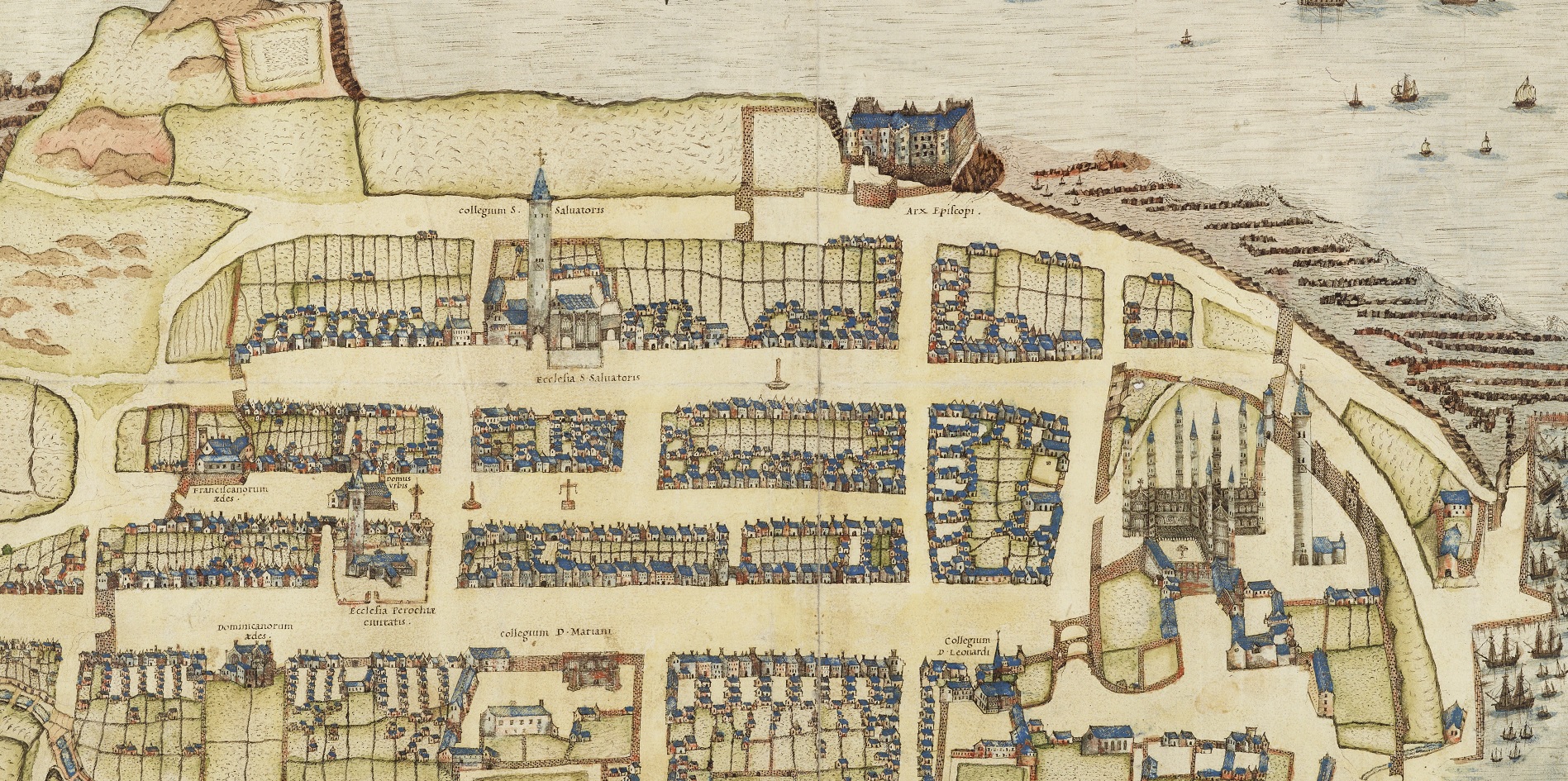
The town of St Andrews and the many distinctive buildings which we can see lining the streets are relatively unchanged from how they looked around 500 years ago. Despite being a larger town now than it was in the past, the essence of town has remained so unchanged that the basic layout of the town can still be recognised in the map “S. Andre sive Andreapolis Scotiae Universitas Metropolitana.” drawn by John Geddy (or Geddes).
This map is held in the National Library of Scotland (MS.20996) and is particularly important as it is among several detailed early maps drawn of Scotland in the sixteenth century. The Geddy map is considered by scholars to be the earliest significantly detailed Scottish map representing a Scottish town, and is important as it shows what the town was like in the early 1580s.
What we know about Geddy is that he was probably born in St Andrews and studied at St Leonard’s College from 1571 to 1574. He worked as amanuensis (someone who is a literary/artistic assistant who writes down what someone is saying, or copies manuscripts) to George Buchanan, the well-known Scottish historian and poet, and served James VI, probably in a diplomatic capacity.
If you take a close look at the Geddy map, you’ll see that some parts of the town considered important by the mapmaker are given rather fancy latin names such as ‘Collegium D Leonardi’ (St Leonard’s College) and ‘Collegium Di Mariani’ (St Mary’s College) . The three main streets, North Street, Market Street and South Street, may be seen converging upon the (still unruined) Cathedral. St Salvator’s Chapel and the Archbishop’s Castle are clearly visible. If we look closely though, there are major differences between then and now. Firstly, the castle is still there, and at this time it was in a state of disrepair but it was not as ruinous as we see it today. Secondly, that the town is surrounded by a wall, and that the town was comprised of fewer houses then than it has today. It is quite fun to look at how St Andrews has changed over time, perhaps you could give it a go and see what other differences you can spot?
So, how were maps like the Geddy Map drawn? Think of how you would figure out what a town looks like from the air without having access to Google Earth! At the time, maps like this one weren’t particularly accurate and were usually drawn by taking measurements between points of noteworthiness. Sometimes maps drawn during this period were inaccurate and they often tell us quite a lot about the society which made the maps than the place the map is illustrating. This is because maps are made within a social and political context, and therefore they often (intentionally or otherwise) highlighted points of interest in a way communicate a narrative about what is considered important/valued by the person who made the map or the society the map is made for – resulting in the map representing more than the geography it depicts.
In the Geddy map for example, the churches are given extra importance by being drawn disproportionately bigger than the generic houses we can see lining the streets, and there are lots more ships in the sea than there probably would’ve been. At the time the map was made, the church was encouraging map-making. Ships flying crossed flags can be seen, and there are perhaps more drawn than would have actually been in St Andrews bay at the time, for the sake of artistic license or perhaps to display the naval strength of the country. There’s even what looks to be a mysterious fin in the water, what do you think it is? It might be a mermaid’s tail, and it might have been added to make a nod to Scottish myths and legends. In this way the Geddy Map acts as a sort-of-accurate and sort-of-illustrative map.
Nowadays, computers are usually used to make our maps, but that doesn’t mean you can’t try to draw one by hand yourself. How would you draw the town? And what would you include?
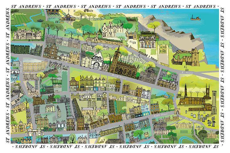
The Geddy Map is reflected in the modern times through Perth-based artist Sarah Halliday’s work. Using modern techniques, and a computer, she has drawn a map of St Andrews from the aerial perspective. Like the Geddy Map, her map has an illustrative quality, however Sarah’s is much more. Her illustration of the town is colourful and modern, and includes distinctive parts of the town which people may have fond memories of (such as Janetta’s!).
This blending of the old and the new can be seen in Sarah’s experience of mediums and techniques. Sarah is a trained fine artist in the age-old medium of oil who believes in bringing fine art to audiences on beautiful, yet useful, products. Frustrated by the inability to print her work without colour shifts, she started experimenting with Adobe Illustrator, which has allowed her to be able to print on textiles and other materials. Using the modern medium of Digital Art has enabled her to put her artwork on fabric and stationery much easier and she has been steadily expanding her range of products beyond her fine art. Sarah describes her work as, ‘Classic skills with a modern approach’.
Despite being made by different people, in different styles and techniques, both maps illustrate the same town around 500 years apart. Indeed, when taken together the maps illustrate the contrast between the old and the new, illustrate the passage of time in a visual way allowing us to spot the similarities and differences between the town then and now. Both maps are a little pieces of the history and evolution of St Andrews, and perfectly encapsulate the coming together of the old and the new which we see so much in the town today.
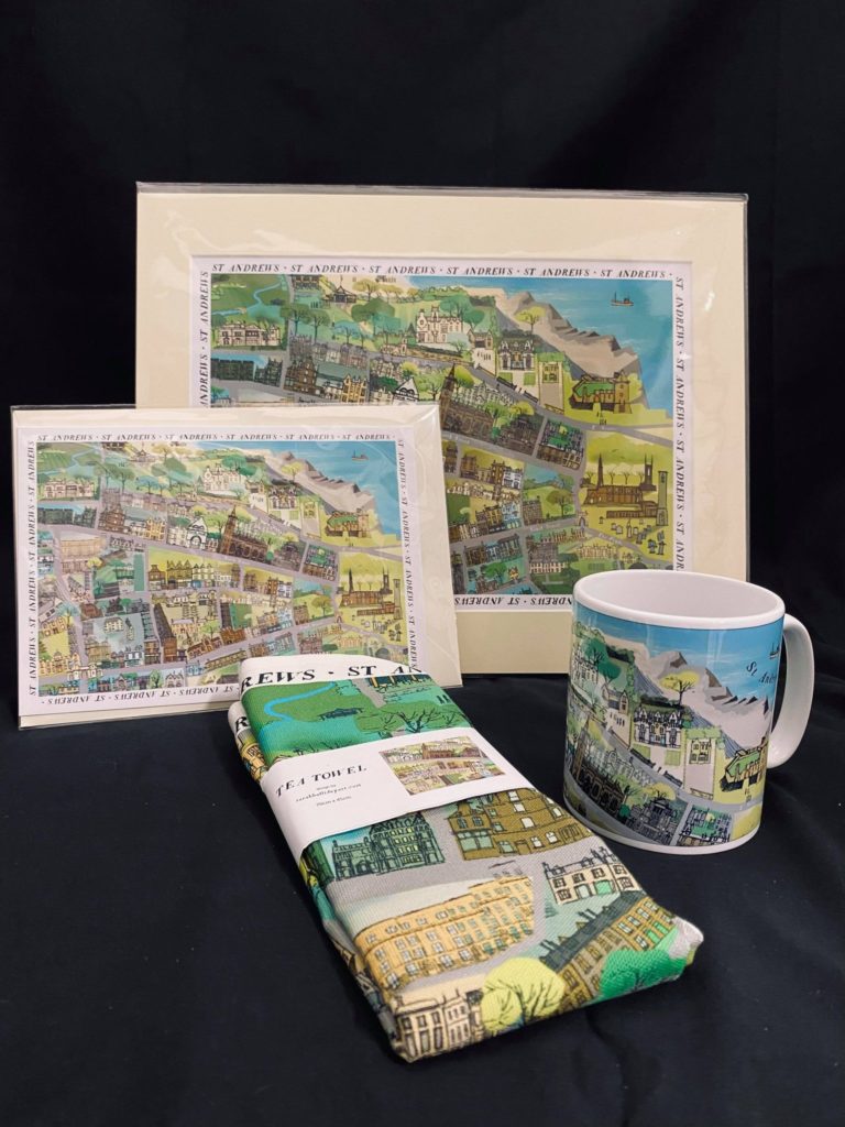
If you like the look of Sarah Halliday’s map, and would like to have your own bit of St Andrews in your home, check out our Wardlaw Museum Shop online. Our Wardlaw Museum Shop has a beautiful range of products inspired by our collections and scenic location. There you can find tea towels, mugs, postcards, and prints decorated with Sarah Halliday’s map of St Andrews, and lots more thoughtful and affordable gifts which can be purchased from our museum shop website.
Discover more from Museums Blog
Subscribe to get the latest posts sent to your email.